File:Leonhard Euler World Map AD1760.jpg

Tamaño di bista previo: 696 × 599 pixels. Otro resolushon: 279 × 240 pixels | 557 × 480 pixels | 892 × 768 pixels | 1,189 × 1,024 pixels | 2,378 × 2,048 pixels | 2,615 × 2,252 pixels.
Fail original (2,615 × 2,252 pixel, tamaño di fail: 2.79 MB, MIME type: image/jpeg)
Resúmen
| Deskripshon |
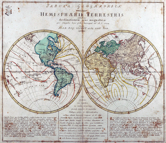
Tabula Geographica utriusque Hemisphaerii Terrestris exhibens declinationem acus magneticae pro singulis locis globi terraquei ad A. C. 1744. Iussu Acad: Reg: Scient: et El: Litt: Bor: descripta. Deutsch: Kupferstich-Weltkarte von Leonhard Euler aus seinem Schulatlas Geographischer Atlas bestehend in 44 Land-Charten erstmals 1753 in Berlin erschienen
English: Engraved world map (including magnetic declination lines) by Leonhard Euler from his school atlas “Geographischer Atlas bestehend in 44 Land-Charten” first published 1753 in Berlin |
||||||||||||||||||||||||||
| Fecha | |||||||||||||||||||||||||||
| Fuente | Antique-World: Antique World Map by Leonhard Euler | ||||||||||||||||||||||||||
| Outor |
|
||||||||||||||||||||||||||
| Pèrmit (Ta re-utilisá e fail akí) |
Own work | ||||||||||||||||||||||||||

Lisensia
|
This work is in the public domain in its country of origin and other countries and areas where the copyright term is the author's life plus 100 years or fewer. This work is in the public domain in the United States because it was published (or registered with the U.S. Copyright Office) before January 1, 1929. | |
| This file has been identified as being free of known restrictions under copyright law, including all related and neighboring rights. | |
Historia di fail
Klek riba un fecha/ora pa mira e fail, manera e tabata na e momentu ei.
| Fecha/Ora | Miniatura | Dimenshonnan | Usuario | Komentario | |
|---|---|---|---|---|---|
| aktual | 02:08, 26 aprel 2008 | | 2,615 × 2,252 (2.79 MB) | Ray007 | == Summary == {{Information |Description={{de|Kupferstich Weltkarte von Leonahrd Euler aus seinem Schulatlas "Geographischer Atlas bestehend in 44 Land-Charten" erstmals 1753 in Berlin erschienen}} {{en|Engraved world map by Leonahrd Euler from his school |
| 01:39, 26 aprel 2008 |  | 3,504 × 2,336 (4.88 MB) | Ray007 | {{Information |Description={{de|Kupferstich Weltkarte von Leonahrd Euler aus seinem Schulatlas "Geographischer Atlas bestehend in 44 Land-Charten" erstmals 1753 in Berlin erschienen}} {{en|Engraved world map by Leonahrd Euler from his school atlas "Geogra |
Uso di fail
E próksimo page uses ta uza e fail akí:
Uso global di fail
E próksimo otro wikinan ta usa e fail akí
- Uso na ar.wikipedia.org
- Uso na ast.wikipedia.org
- Uso na br.wikipedia.org
- Uso na de.wikipedia.org
- Uso na en.wikipedia.org
- Uso na eo.wikiquote.org
- Uso na eu.wikipedia.org
- Uso na fr.wikipedia.org
- Uso na ia.wikipedia.org
- Uso na ko.wikipedia.org
- Uso na ru.wikipedia.org
- Uso na sh.wikipedia.org
- Uso na sr.wikipedia.org
- Uso na tr.wikipedia.org
- Uso na www.wikidata.org