File:Tt-map.png
No tin resolushon mas mihó.
Tt-map.png (324 × 350 pixel, tamaño di fail: 4 KB, MIME type: image/png)
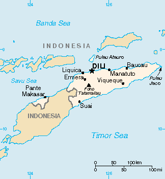
| Deskripshon | Map of East Timor (wp-EN). | |||
| Fecha | Unknown date | |||
| Fuente | Original map in the CIA World Factbook (wp-EN). | |||
| Outor | CIA World Factbook | |||
| Pèrmit (Ta re-utilisá e fail akí) |
|
|||
| Other versions |
|

Historia di fail
Klek riba un fecha/ora pa mira e fail, manera e tabata na e momentu ei.
| Fecha/Ora | Miniatura | Dimenshonnan | Usuario | Komentario | |
|---|---|---|---|---|---|
| aktual | 15:05, 13 mart 2022 | | 324 × 350 (4 KB) | Lojwe | Cropped 2 % horizontally, 1 % vertically using CropTool with precise mode. |
| 19:59, 5 mart 2005 |  | 330 × 355 (5 KB) | Alfio | CIA map of East Timor |
Uso di fail
E próksimo page uses ta uza e fail akí:
Uso global di fail
E próksimo otro wikinan ta usa e fail akí
- Uso na ckb.wikipedia.org
- Uso na en.wikipedia.org
- Uso na en.wikinews.org
- Uso na fa.wikipedia.org
- Uso na gl.wikipedia.org
- Uso na he.wikipedia.org
- Uso na hu.wikipedia.org
- Uso na id.wikipedia.org
- Uso na it.wikipedia.org
- Uso na jv.wikipedia.org
- Uso na map-bms.wikipedia.org
- Uso na mzn.wikipedia.org
- Uso na sv.wikipedia.org
- Uso na tr.wiktionary.org
- Uso na udm.wikipedia.org
- Uso na vi.wikipedia.org