File:Vanatinai, Louisiade Archipelago.jpg

Tamaño di bista previo: 800 × 533 pixels. Otro resolushon: 320 × 213 pixels | 640 × 427 pixels | 1,024 × 683 pixels | 1,280 × 853 pixels | 2,560 × 1,707 pixels | 3,600 × 2,400 pixels.
Fail original (3,600 × 2,400 pixel, tamaño di fail: 2.93 MB, MIME type: image/jpeg)
Resúmen
| Deskripshon |
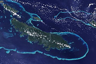
English: The lower corner of the scene shows part of the northwestern coast of the largest island in the archipelago, Vanatinai. Most of the island is densely covered in lowland rainforest, but clearing for agricultural land is widespread around the perimeter, especially in the northwest. The shallow waters covering an extensive network of reefs are electric blue. A sinuous channel of deep, clear water (image center) connects a partially enclosed lagoon north of Vanatinai with the bay south of Yeina Island. |
| Fecha | |
| Fuente | NASA Earth Observatory |
| Outor | NASA image by Jesse Allen and Rob Simmon, using data provided by the United States Geological Survey. |
Instrument: Landsat 7 - ETM+
Lisensia
| This file is in the public domain in the United States because it was solely created by NASA. NASA copyright policy states that "NASA material is not protected by copyright unless noted". (See Template:PD-USGov, NASA copyright policy page or JPL Image Use Policy.) | ||
 |
Warnings:
|
Historia di fail
Klek riba un fecha/ora pa mira e fail, manera e tabata na e momentu ei.
| Fecha/Ora | Miniatura | Dimenshonnan | Usuario | Komentario | |
|---|---|---|---|---|---|
| aktual | 12:34, 26 aprel 2009 | | 3,600 × 2,400 (2.93 MB) | Originalwana | {{Information |Description={{en|1=The lower corner of the scene shows part of the northwestern coast of the largest island in the archipelago, Vanatinai. Most of the island is densely covered in lowland rainforest, but clearing for agricultural land is wi |
Uso di fail
E próksimo page uses ta uza e fail akí:
Uso global di fail
E próksimo otro wikinan ta usa e fail akí
- Uso na ar.wikipedia.org
- Uso na arz.wikipedia.org
- Uso na ca.wikipedia.org
- Uso na ceb.wikipedia.org
- Uso na cy.wikipedia.org
- Uso na de.wikipedia.org
- Uso na en.wikipedia.org
- Uso na eo.wikipedia.org
- Uso na es.wikipedia.org
- Uso na et.wikipedia.org
- Uso na fa.wikipedia.org
- Uso na fi.wikipedia.org
- Uso na fr.wikipedia.org
- Uso na he.wikipedia.org
- Uso na ia.wikipedia.org
- Uso na id.wikipedia.org
- Uso na it.wikipedia.org
- Uso na kw.wikipedia.org
- Uso na lv.wikipedia.org
- Uso na nl.wikipedia.org
- Uso na pl.wikipedia.org
- Uso na simple.wikipedia.org
- Uso na uk.wikipedia.org
- Uso na vi.wikipedia.org
- Uso na vls.wikipedia.org
- Uso na www.wikidata.org
- Uso na zh.wikipedia.org