File:WorldEmpires.png
Tamaño di bista previo: 800 × 480 pixels. Otro resolushon: 320 × 192 pixels | 1,024 × 614 pixels | 1,280 × 768 pixels | 3,000 × 1,800 pixels.
Fail original (3,000 × 1,800 pixel, tamaño di fail: 561 KB, MIME type: image/png)
Resúmen
| Deskripshon |
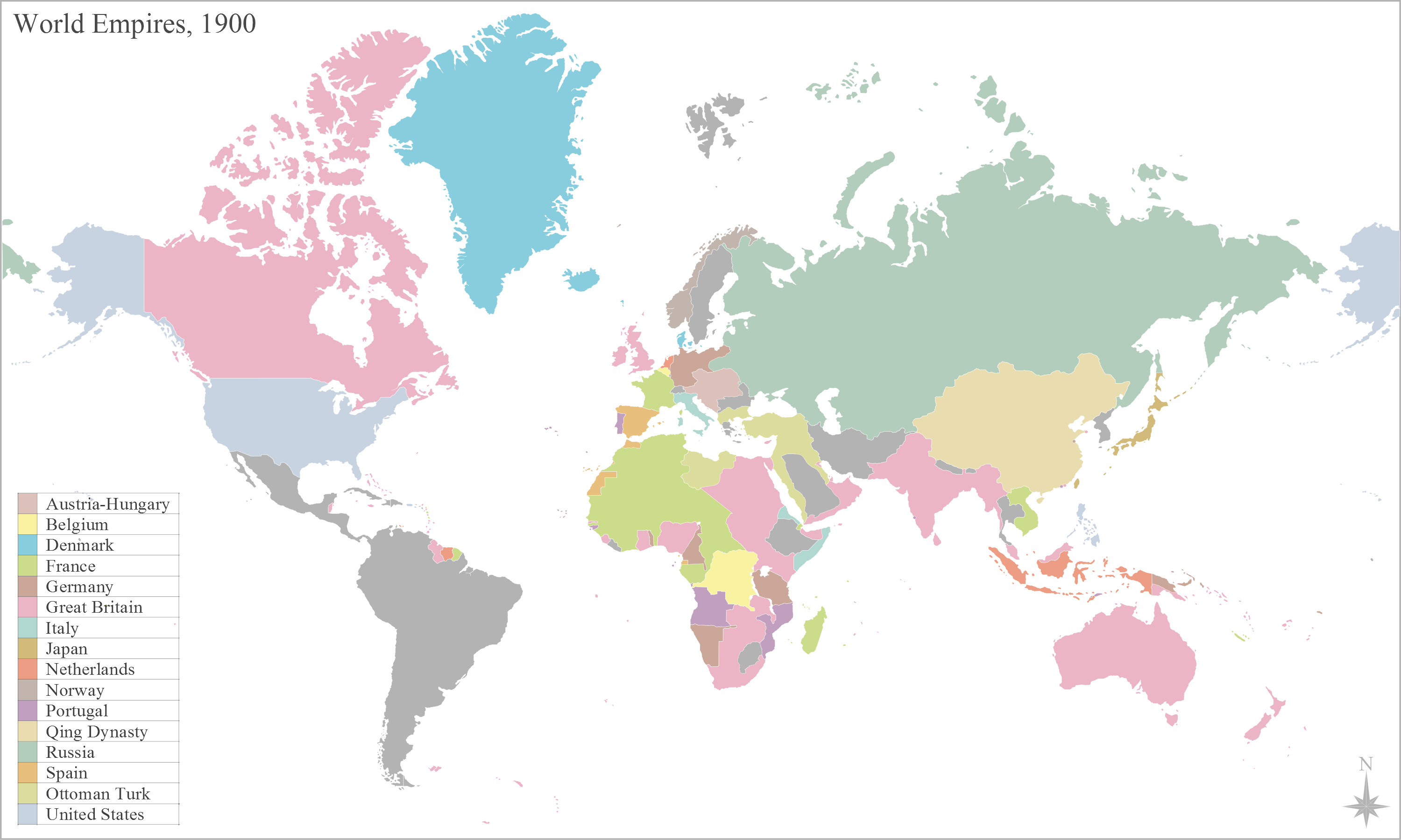
English: Map of the worlds empires, during 1900 |
| Fecha | |
| Fuente | Obra propio |
| Outor | George Bosanko |
Lisensia
I, the copyright holder of this work, hereby publish it under the following license:
E fail akí tin lisensia Creative Commons Attribution-Share Alike 3.0 Unported.
- Bo ta liber:
- pa kompartí – pa kopia, distribuí i transmití e obra
- pa rekombiná – pa adaptá e obra
- Di akuerdo ku e próksimo kondishonnan:
- atribushon – Bo mester duna krédito na e outor, duna un lenk na e lisensia, i indiká si a hasi kambio. Bo por hasi esei na kualke manera rasonabel, perono na manera ku por sugerí ku esun ku ta otorgá e lisensia ta respaldá abo òf bo uzo.
- kompartí meskos – Si bo meskla, transfrmáòf modifiká e obra bo mester distribuí bo kontribushonnan bou di [mes lisensia https://creativecommons.org/share-your-work/licensing-considerations/compatible-licenses òf unu kompatibel] ku esun original.
Historia di fail
Klek riba un fecha/ora pa mira e fail, manera e tabata na e momentu ei.
| Fecha/Ora | Miniatura | Dimenshonnan | Usuario | Komentario | |
|---|---|---|---|---|---|
| aktual | 12:21, 29 yanüari 2014 | | 3,000 × 1,800 (561 KB) | Alphathon | Reverted to version as of 16:17, 2 June 2012. Numerous errors introduced (e.g. Nicaragua part of US, Ottoman Empire renamed Turkey) and some changes which don't apply accross whole (newly intorduced) time span (e.g. Italian Libya, non-Ottoman Balkans) |
| 02:25, 18 ougùstùs 2013 |  | 3,000 × 1,800 (674 KB) | Mttll | Fixed legend | |
| 16:17, 2 yüni 2012 |  | 3,000 × 1,800 (561 KB) | GBozanko | Change date and fixes to coincide with that; Added Qing Dynasty; removal of Transvaal and Orange Free State from British South Africa; addition of Ottoman European Territories; removal of US administration of Nicaragua; fix of British Nigeria and Germa... | |
| 15:24, 26 mei 2012 |  | 3,000 × 1,800 (559 KB) | Geord0 | Harmonious with 'British Somaliland 1884–1960' article, and sourced map from the United Kingdom National Archive 'maps in time' http://www.nationalarchives.gov.uk/cabinetpapers/themes/maps-interactive/maps-in-time.htm | |
| 14:35, 26 mei 2012 |  | 801 × 480 (111 KB) | Runehelmet | British Somaliland and North Western part of Italian Somaliland were under control of the Dervish State in the given timeline. | |
| 15:30, 19 mei 2012 |  | 3,000 × 1,800 (559 KB) | Geord0 |
Uso di fail
E próksimo page uses ta uza e fail akí:
Uso global di fail
E próksimo otro wikinan ta usa e fail akí
- Uso na af.wikipedia.org
- Uso na ar.wikipedia.org
- إمبراطورية
- بوابة:الإمبراطورية الروسية
- بوابة:الإمبراطورية الروسية/بوابات شقيقة
- بوابة:الإمبراطورية الألمانية
- بوابة:الإمبراطورية الألمانية/بوابات شقيقة
- بوابة:إمبراطورية اليابان
- بوابة:إمبراطورية اليابان/بوابات شقيقة
- بوابة:الخلافة الراشدة
- بوابة:الدولة الأموية
- بوابة:الإمبراطورية الفرنسية الأولى/بوابات شقيقة
- بوابة:الإمبراطورية الفرنسية الأولى
- بوابة:الإمبراطورية النمساوية/بوابات شقيقة
- بوابة:الإمبراطورية النمساوية
- بوابة:الإمبراطورية البريطانية
- بوابة:الإمبراطورية البريطانية/بوابات شقيقة
- بوابة:الإمبراطورية الفرنسية الثانية
- بوابة:الإمبراطورية الفرنسية الثانية/بوابات شقيقة
- بوابة:الإمبراطورية البرتغالية
- بوابة:الإمبراطورية البرتغالية/بوابات شقيقة
- بوابة:الإمبراطورية النمساوية المجرية
- بوابة:الإمبراطورية النمساوية المجرية/بوابات شقيقة
- بوابة:الإمبراطورية المغولية
- بوابة:الإمبراطورية المغولية/بوابات شقيقة
- بوابة:الإمبراطورية الإسبانية
- بوابة:إمبراطوريات
- بوابة:إمبراطوريات/واجهة
- بوابة:إمبراطوريات/بوابات شقيقة
- بوابة:الإمبراطورية الإسبانية/بوابات شقيقة
- بوابة:الدولة الأموية/بوابات شقيقة
- بوابة:الخلافة الراشدة/بوابات شقيقة
- بوابة:مملكة فرنسا
- بوابة:مملكة فرنسا/بوابات شقيقة
- بوابة:الإمبراطورية الرومانية المقدسة
- بوابة:الإمبراطورية الرومانية المقدسة/بوابات شقيقة
- قالب:بوابات الإمبراطوريات
- Uso na azb.wikipedia.org
- Uso na ca.wikipedia.org
- Uso na en.wikipedia.org
- Uso na es.wikipedia.org
- Uso na gom.wikipedia.org
- Uso na hy.wikipedia.org
Mira mas uzo global di e fail akí.