File:World map 1815 (COV).jpg

Fail original (4,000 × 2,304 pixel, tamaño di fail: 1.49 MB, MIME type: image/jpeg)
.jpg)
Resúmen
| Deskripshon |
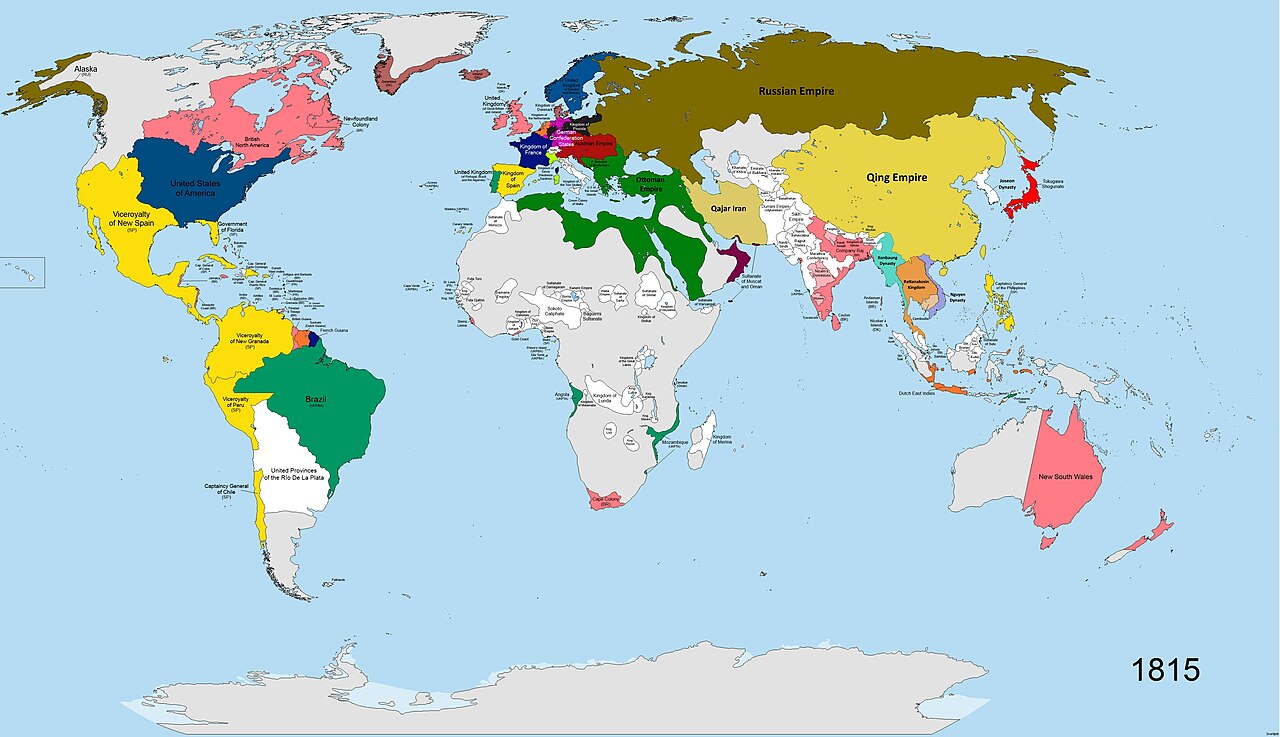
English: A map of the world in the year 1815 AD. States shown in colours:
Britain (pink), France (navy blue), Sweden (dark blue), Prussia (dark grey), the states of the German Confederation (pink), Austria (burgundy), Spain (yellow), Portugal (green-turquoise), Ottoman Empire (dark green), Iran (light green), Russia (brown), Netherlands (orange), Sardinia/Savoy (lime green), China (cream-yellow), Japan (bright red), Denmark (dull red), Oman (maroon-purple), USA (dark blue, similar to Sweden). All other states shown in white. Terra Nullis shown in grey. |
| Fecha | |
| Fuente | Obra propio |
| Outor | SvoHljott |
Map covers entire globe. Research for accuracy took 5 months. Borders are as accurate as possible, where no maps of the individual states at the time existed, borders are based on rivers and cities.
| Maps of world history | |
| BC | |
|
| |
| AD |
1 · 50 · 100 · 200 · 250 · 300 · 400 · 500 · 700 · 750 · 820 · 900 · 1200 · 1500 · 1556 · 1648 · 1700 · 1750 · 1815 · 1859 · 1871 · 1914 · 1935 · 1989 · 2000 · |
|
Maps of colonization history | |
|
see also: Eastern Hemisphere only maps template (1300BC-1500AD) | |
| (this template: · view · discuss ) | |
._LOC_2001620596.jpg)
Lisensia
- Bo ta liber:
- pa kompartí – pa kopia, distribuí i transmití e obra
- pa rekombiná – pa adaptá e obra
- Di akuerdo ku e próksimo kondishonnan:
- atribushon – Bo mester duna krédito na e outor, duna un lenk na e lisensia, i indiká si a hasi kambio. Bo por hasi esei na kualke manera rasonabel, perono na manera ku por sugerí ku esun ku ta otorgá e lisensia ta respaldá abo òf bo uzo.
- kompartí meskos – Si bo meskla, transfrmáòf modifiká e obra bo mester distribuí bo kontribushonnan bou di [mes lisensia https://creativecommons.org/share-your-work/licensing-considerations/compatible-licenses òf unu kompatibel] ku esun original.
Historia di fail
Klek riba un fecha/ora pa mira e fail, manera e tabata na e momentu ei.
| Fecha/Ora | Miniatura | Dimenshonnan | Usuario | Komentario | |
|---|---|---|---|---|---|
| aktual | 12:32, 28 mart 2023 | | 4,000 × 2,304 (1.49 MB) | Yourlocallordandsavior | Minor tweaks. |
| 12:18, 28 mart 2023 |  | 4,000 × 2,304 (1.5 MB) | Yourlocallordandsavior | Improved Mainland SE Asia's borders. | |
| 08:43, 19 mart 2023 |  | 4,000 × 2,304 (896 KB) | Achim55 | Reverted to version as of 17:26, 3 October 2020 (UTC) | |
| 06:15, 18 mart 2023 |  | 4,500 × 2,592 (2.51 MB) | Dndnrmn1 | Reverted to version as of 17:57, 1 May 2014 (UTC) | |
| 17:26, 3 òktober 2020 |  | 4,000 × 2,304 (896 KB) | Ориенталист | minor coppections | |
| 17:57, 1 mei 2014 |  | 4,500 × 2,592 (2.51 MB) | SvoHljott | Added Company Raj label. | |
| 14:33, 1 mei 2014 |  | 4,500 × 2,592 (2.5 MB) | SvoHljott | Added labels for Cape Verde, the Falklands, the Guianas and Goa. | |
| 12:45, 1 mei 2014 |  | 4,500 × 2,592 (1.45 MB) | SvoHljott | Added Sao Tome and Principe, Bioko and the African Great Lake States labels. | |
| 12:15, 1 mei 2014 |  | 4,500 × 2,592 (1.45 MB) | SvoHljott | User created page with UploadWizard |
Uso di fail
E próksimo page uses ta uza e fail akí:
Uso global di fail
E próksimo otro wikinan ta usa e fail akí
- Uso na de.wikipedia.org
- Uso na en.wikipedia.org
- Uso na es.wikipedia.org
- Uso na eu.wikipedia.org
- Uso na lv.wikipedia.org
- Uso na nl.wikipedia.org
- Uso na sr.wikipedia.org
.jpg)